
Every map on this page is live. They update themselves from NOAA, the National Weather Service and the hurricane, storm-prediction and satellite centers — the same public feeds every weather site in the country runs on — and they are here so you can call tomorrow’s trip without opening eight tabs.
What we have added is the part those agencies do not write: what each product actually means when you are standing at a ramp in Sarasota at six in the morning. Wind decides where you can fish. Radar and lightning decide whether you go at all. Water temperature decides what is biting. In roughly that order.
Start with wind — it decides everything else
Live wind model — centered on Sarasota
An interactive ECMWF model map. Drag it, zoom it, and scrub the timeline along the bottom to step forward hour by hour. Switch the overlay to waves, gusts or rain from the menu on the right.
HereSustained wind is the single number that decides your day. Under 10 knots you can fish open water anywhere. From 10 to 15 you start picking protected shorelines. Above 15 you are on lee mangrove edges and in canals, and the Gulf is off the table for a flats boat. Scrub the slider to find the morning window — most summer days are flat at dawn and blowing 10 to 15 by early afternoon, which is exactly why the good boats leave at first light.
Live from Windy.com
Windy shows you models. It is not the forecast of record — that is written by humans at the NWS Tampa Bay office in Ruskin, who watch this specific coast and split it into marine zones. Two habits are worth building: compare the models, and believe the pessimistic one. When GFS and ECMWF agree on tomorrow’s wind, trust it. When they split, plan for the worse.
| Zone | Coverage | Who uses it |
|---|---|---|
| GMZ853 | Englewood → Tarpon Springs, 0–20 NM | Sarasota / AMI inshore, beach and nearshore — the default zone |
| GMZ873 | Englewood → Tarpon Springs, 20–60 NM | Sarasota offshore trips |
| GMZ856 | Bonita Beach → Englewood, 0–20 NM | Venice south to Boca Grande nearshore |
| GMZ876 | Bonita Beach → Englewood, 20–60 NM | Southern offshore grounds |
| GMZ830 | Tampa Bay waters | Skyway and lower Tampa Bay out of Anna Maria Island |
| GMZ836 | Charlotte Harbor and Pine Island Sound | Harbor tarpon and flats trips |
Read it three ways: the plain-text GMZ853 forecast loads on any connection and on any phone signal — swap the zone code in that URL for any other zone; the full TBW coastal waters forecast puts every zone on one page; and the NWS Tampa Bay marine page adds graphics and active hazards. The zone map itself is at weather.gov/marine/tbwmz.
Wind does more than make you uncomfortable. Sustained wind physically pushes water onto and off the flats, which can add or cancel a foot of predicted tide — that interaction is covered in the tides and currents guide.
Storms build inland over the interior, then walk west toward the coast.
Radar — the go / no-go call
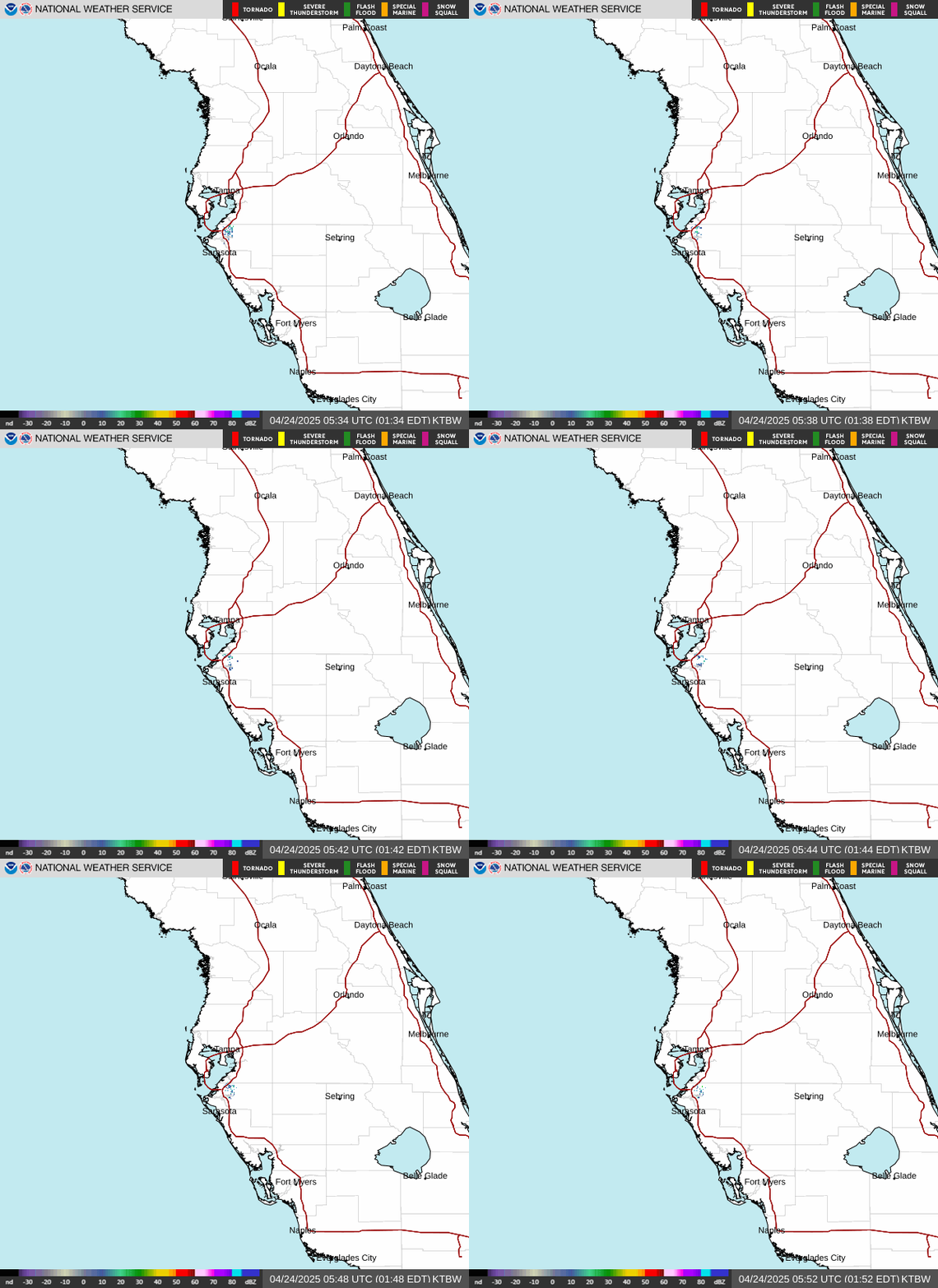
Ruskin radar loop (KTBW)
A live animated loop from the National Weather Service radar at Ruskin, on the east side of Tampa Bay. It covers the entire Suncoast from Tampa to Charlotte Harbor and refreshes every few minutes.
HereThe summer pattern here is predictable enough to plan around. Storms fire over the interior in the early afternoon, and the only question is whether the Gulf sea breeze holds them inland or steers them west across the bay. Check it at the ramp, and again the moment the horizon darkens — a June cell crosses Sarasota Bay faster than a 60-horse skiff can run home.
Live from NOAA / National Weather Service

Lightning mapper — live strike density
The Geostationary Lightning Mapper aboard GOES-19 detects flashes from orbit and paints where they are landing across the Southeast, day and night.
HereThis is the non-negotiable one. The Gulf coast of Florida produces some of the densest lightning in the United States every summer, and a graphite rod on an open boat is the tallest thing for a mile. If you can hear thunder you are already in range. Night trips get the same rule — a cell that fires after dark is invisible until it lights up, so the run home starts at the first flash on the horizon, not the first raindrop.
Live from NOAA NESDIS / GOES-19

GOES-19 satellite — the Gulf, right now
True-color satellite imagery of the Gulf of Mexico, updating continuously. At night it switches automatically to an infrared product, so the picture never goes dark.
HereRadar tells you what is raining. Satellite tells you what is coming and what the sky will do to your fishing. Look at it for two things: the line of the sea breeze boundary, which is where the afternoon storms will fire, and whether tomorrow is going to be a bluebird high-sun day — which is what you want for sight fishing and exactly what you do not want for a topwater morning.
Live from NOAA NESDIS / GOES-19
The water itself — buoys, seas and temperature
Forecasts guess. Buoys report. This is the difference between a forecast that says two feet and a dawn reading that already says three and a half — and when they disagree, the buoy wins.
| Buoy | Position | What it gives you |
|---|---|---|
| 42013 — C10, West Florida Shelf | 27.173°N 82.924°W · ~25 NM west of Sarasota on the 25-metre line | Wind, waves and water temperature — the closest offshore truth we have. A USF COMPS buoy |
| 42036 — West Tampa | 28.500°N 84.505°W · 112 NM WNW of Tampa | Deep-water swell reference — what is coming before it gets here |
| VENF1 — Venice | Venice, at the inlet | Nearshore wind at the south end of our range |
| PMAF1 — Port Manatee | Lower Tampa Bay | Bay-side wind at the north end |
Read 42013 before any Gulf run. The full state index is at NDBC’s Florida stations page, and raw C10 archives live on SECOORA’s ERDDAP server if you want history rather than current conditions.
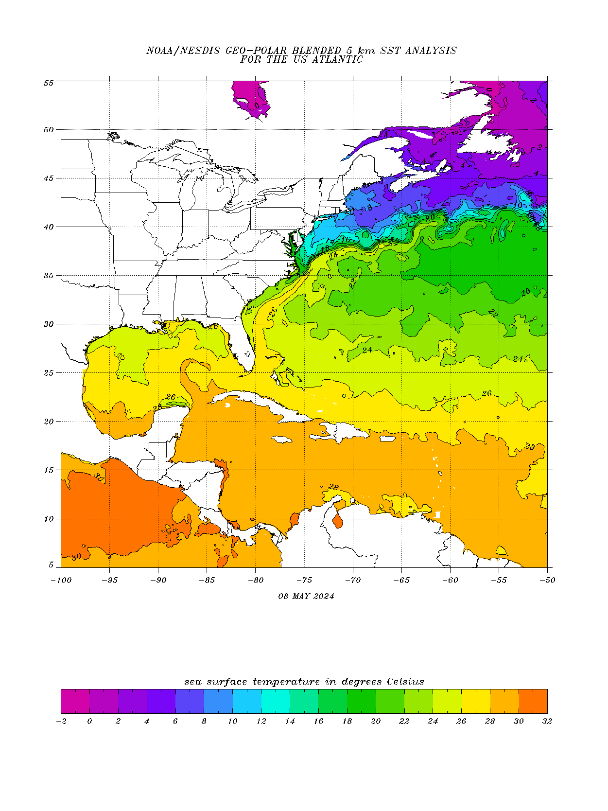
Sea surface temperature — Gulf and Atlantic
A NOAA contour analysis of sea surface temperature. The lines are isotherms — each one joins water of the same temperature — so you can see where warm and cool water meet.
HereWater temperature runs the whole calendar on this coast. Snook wake up and move to the beaches as the water climbs through the low 70s; tarpon show along the beaches behind them; kingfish run when it hits the low 70s in spring and again on the way down in fall; and when it drops below the mid-60s the sheepshead and black drum take over the structure. One degree is the difference between a run being on and being a week away.
For live in-the-water numbers rather than a basin-wide analysis: buoy 42013 reports Gulf surface temperature on the 25-metre line, and the St. Petersburg station’s physical oceanography page reports live water temperature inside Tampa Bay — the best real-time proxy for our own bays.
The models most anglers have never heard of
The USF Ocean Circulation Lab runs free forecast models out of St. Petersburg that almost nobody outside the research community checks.
| Model | What it forecasts |
|---|---|
| WFCOM | Currents and conditions from the open Gulf across the shelf and into the estuaries — daily nowcast plus a 3.5-day forecast |
| TBCOM | A higher-resolution Tampa Bay model nested inside WFCOM |
| Sea level guidance | Water level and surge outlook |
The sea level guidance is the one that earns its bookmark. When a front or a distant storm is pushing water around, it tells you whether the negative low tide you planned your morning around is actually going to happen — which decides whether the flats skiff floats off the trailer at all. The full index is at ocl.marine.usf.edu/models.html. The same group runs the red tide trajectory forecast.
Hurricane season — June through November

Tropical weather outlook — 7 day
The National Hurricane Center's graphical outlook. Shaded areas are systems they are watching, colour-coded by the chance of tropical development over the next seven days. If the Atlantic and Gulf are quiet, this map is empty — which is the normal state most of the year.
HereFor fishing purposes a distant storm matters long before it is a local threat. A hurricane a thousand miles away pushes swell and dirty water onto this coast days ahead of itself, and a system in the Gulf shuts down the offshore fleet for a week. In the other direction, the days right after a front or a blow can be some of the best fishing of the year once the water clears.
Seasonal. The Atlantic hurricane season runs June 1 to November 30, and this map is usually blank outside it.
Live from NOAA National Hurricane Center

Severe watches — tornado and severe thunderstorm
Every active severe thunderstorm and tornado watch box in the country, straight from the Storm Prediction Center. Like the tropical map, an empty picture is good news.
HereFlorida's severe weather is mostly a winter and spring story, when strong cold fronts sweep across the peninsula and can spin up waterspouts and squall lines over the Gulf. Those fronts are also what makes the fishing before them so good and the fishing after them so hard. If a box is drawn over Sarasota, that is a stay-home day, not a fish-the-lee-shore day.
Live from NOAA Storm Prediction Center
The pre-trip check, in order
Ten minutes the night before, five at dawn. In this order, because each one can cancel the next.
| # | Check | Tool | Go / no-go signal |
|---|---|---|---|
| 1 | Zone forecast | GMZ853 text | A small craft advisory means a bay day, not a Gulf day |
| 2 | Live buoy | 42013 | Seas already above forecast — believe the buoy, not the forecast |
| 3 | Wind models | Windy, above | Do GFS and ECMWF agree, and how long is the morning window |
| 4 | Radar and lightning | KTBW loop, above | Anything inbound within an hour of your run |
| 5 | Tide and water level | Tides guide | Match the moving-water window to the spot you picked |
| 6 | Red tide, especially June–February | Red tide check | A bloom at your launch means move north or south |
FAQ
What is the marine forecast zone for Sarasota? GMZ853 — Englewood to Tarpon Springs, out to 20 nautical miles. Past 20 NM it becomes GMZ873. Both are written by the NWS Tampa Bay office in Ruskin.
What buoy is closest to Sarasota? NDBC 42013, also called C10, roughly 25 nautical miles west of Sarasota at the 25-metre depth line. It reports wind, waves and water temperature in near real time.
How much wind is too much for inshore fishing in Sarasota? Sustained 15 knots is the working ceiling for comfortable open-bay fishing in a flats boat. Above that, fish lee shorelines and protected water. Small craft advisories typically fly around 20 knots and up.
When is the calmest time to fish in summer? Dawn to late morning. The Gulf sea breeze usually builds to 10–15 knots by early afternoon and the inland storms follow it. The flat window is first light.
Is Windy accurate for Sarasota? Windy displays global models — GFS and ECMWF — which are good for wind trends and poor at local sea-breeze detail, because the sea breeze happens at a scale finer than the model grid. Cross-check the NWS zone forecast and buoy 42013 before trusting any single source.
Where does all of this data come from? Every live map on this page is a public feed from a US federal agency — NOAA, the National Weather Service, the National Hurricane Center, the Storm Prediction Center and NOAA’s satellite service — except the wind map, which is Windy’s own free public embed. Nothing here is behind a paywall and nothing is our own measurement.
Related
Wind is half the picture; the water’s own schedule is the other half, covered station by station in the tides and currents guide. In bloom season add the red tide and water quality check. Then put the forecast to work: snook on the calm mornings, redfish on the lee shorelines, and tarpon when the beach finally lays down slick.